With the formation of the integration association of the Eurasian Economic Union (EAEU), the restoration of a common transport space, transport and transit topics acquire special relevance. The development of the transport sector of the countries of the Eurasian Union and Eurasia as a whole determines the need for effective use of transport systems existing in the Eurasian countries and their development towards integration in terms of infrastructure and transport fleet, realization of the advantages of geographical location (primarily the EAEU as occupying a middle position on the continent, coinciding with the location of the notorious geopolitical Heartland) [1, 2]. Wide attention should be paid to the development of water transport as the most economical and environmentally friendly transport.
The creation of a new water transport route (namely, the Volga-Pechora route) can be carried out, fully taking into account the terrain, practically along the shortest distance between the Pechora River (the Arctic Ocean basin) and the full-flowing Volga tributary – the Kama River [3].
The purpose of the study. To highlight the international transport corridors connected with the Volga-Pechersk Way and the Northern Sea Route, as well as to show the effectiveness of their connection with the Silk Road Economic Belt and the possibility of connecting with the global geopolitical project of the Eurasian Canal.
The object of the study. Water transport systems of Russia.
The subject of the study. Volga-Pechersk Way.
Research methods. General logical methods are used as research tools: analysis, synthesis, induction, deduction and analogy, the system method, as well as the research method.
The information base of the research was: scientific sources in the form of data and information from books, journal articles, scientific reports and reports, materials of scientific conferences, seminars, statistical data of the scientific electronic library resource “elibrary.ru
The scientific novelty of the research is determined by the author’s approach to the analysis of the problem, the content of a number of main provisions and conclusions of the work.
Research results and discussion
Development of transport corridors is an urgent task in the transport industry [4]. The heads of the EAEU states approved a strategic document in the transport sector – the main directions and stages of the implementation of a coordinated (agreed) transport policy, within the framework of which a corresponding roadmap is being implemented; in the work of the Eurasian Economic Commission (the coordinating body of the EAEU) with the Parties to the Treaty on the EAEU, in terms of this roadmap, special attention is paid to the problems of the creation and development of Eurasian ITCs.
ITCs directly related to the proposed Volga-Pechora Route project (potentially related to it) are:
• “Northern Sea Route”: Atlantic – Murmansk – Arkhangelsk – Dikson – Tiksi – Pacific Ocean – NSR (this is the international designation of this ITC);
• “North-South”: countries of Central and Northern Europe – European part of Russia – Caspian Sea – Iran – Indian Ocean – NS;
• “New Silk Road” (also referred to as: “Economic Belt of the Silk Road” and “One Belt, One Road”): China – Europe;
• Transsib: European Union – Moscow – Yekaterinburg – Krasnoyarsk – Khabarovsk – Vladivostok and its branch system (to St. Petersburg, South of Russia, Kazakhstan, Mongolia, China). In the Russian Federation, it is interfaced with the Pan-European Transport Corridor No. 2) – TS (the international designation of this ITC based on the Trans-Siberian Railway);
• Pan-European Transport Corridor (PEC) # 2: Berlin – Warsaw – Minsk – Moscow – Nizhny Novgorod – PE2.
In the EAEU part of the Pan-European Transport Corridor No. 2, there are railway and highways from Poland through Belarus to Nizhny Novgorod, including the airports of Minsk, Moscow and Nizhny Novgorod. At present, the extension of PEC No. 2 to Yekaterinburg is being implemented, where PEC is interfaced with the MTC Transsib, and the Transsib railway thus acts as a backbone element for the transport corridor as a whole (a similar role could play in its direction and the Volgo-Pechora path in conjunction with NSR).
NSR is intended for transportation along the route Europe – countries of the Asia-Pacific region, its active navigation period, unfortunately, does not yet exceed two or three months in the annual cycle (due to the presence of perennial ice on the route and the lack of ice required for their effective overcoming icebreaking capacities) [5]. Although the dynamics in the implementation of this ITC is positive and is growing. If implemented, the Volga-Pechora Route will contribute to the development of the Northern Sea Route through an additional load of its traffic and increased shipping along the NSR.
The next ITC, related to the VPR and NSR− ITC North-South topics, is designed to provide transportation from the Indian Ocean regions through Iran and the Caspian Sea with transshipment to the railways of the Russian Federation (or river-sea vessels on Russian inland waterways and Baltic Sea) to European countries. This ITC crosses any latitudinal Eurasian transport corridor and takes a portion of its traffic. The proposed VPR is capable of effectively connecting ITC North-South and the Northern Sea Route [6].
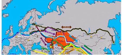
The New Silk Road is a complex of transport routes, implemented primarily by China in cooperation with Russia, Kazakhstan, Belarus, Kyrgyzstan and other Eurasian states. Its purpose is to develop new cargo flows from Southeast Asia to European countries. The transport complex includes a network of railway (railway) routes and highways passing primarily through Kazakhstan and Russia, as well as the capacity of the transcontinental railway Trans-Siberian Railway, which passes through Russia (and partially through Kazakhstan) (Fig. 1).

Fig. 1. Complex of routes of the New Silk Road (shown in white (main route) and “rainbow colors” (secondary)). The Trans-Siberian Railway is shown in dark green
The communication routes in the space of Russia and the EAEU correspond to the shortest geographical distances between the macroregions of Europe and Asia, and thus the geographical location itself favors the development of Eurasian transit. There is an economic need to redirect the volume of passenger and freight traffic in international traffic, increase the competitiveness of carriers of the countries of the Eurasian Union, develop an innovative transport system (network expansion, digitalization), and improve its safe functioning. It should be said that electronic information technologies require early implementation at all stages of the provision of transport services, it is very important to keep up with the new technological wave and not to miss the establishment of the next technological order within the framework of the new scientific and technological revolution [7].
In order to improve the transport system of Russia and expand the transport network of the Eurasian Union (in its water part), it is proposed to implement a project for laying the Volga-Pechora route.
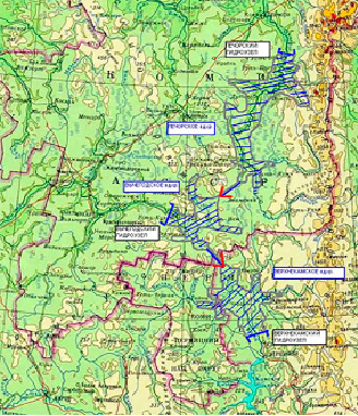
VPR should be implemented by laying a river canal practically along the shortest distance between the Pechora river and the Kama river (the flat relief of this area quite allows this) (Fig. 2).

Fig. 2. Proposed channel of the Volga-Pechora route (junction of the Pechora river with the Volga basin, the Kama river)
The project is designed to promote the development of transboundary river navigation (as well as sea-river navigation), using the potential and available resources of the Northern Sea Route. The project proposal consists in the organization of through ship traffic along the route: Caspian Sea – Volga – Kama – Pechora – Arctic Ocean, which will require separately laying (construction) of the Kama-Pechora navigable canal, which allows the passage of river-sea class vessels , with a displacement of at least 5 thousand tons.
The relevance of the aforementioned project is reinforced precisely by the modern “opening” of the Northern Sea Route, which connects the Pacific and Atlantic oceans, its active promotion to the world transportation market, and the intensification of shipping along its route [8,9]. Climatic changes that have taken place since the beginning of the 3rd millennium, the development of technical means to overcome ice fields and methods of mining in the Arctic Ocean contribute to the development of the infrastructure of the NSR and the increase in transport traffic on this “old-new” sea route and around it.
Now, in the general cargo traffic along the NSR, internal river routes are increasingly involved, incl. already interstate (for example, along the Ob – Irtysh water system; and the Ob and Irtysh are navigable from the border of the Republic of Kazakhstan with China to the Northern Sea Route itself). So, in 2016, two transits of oversized cargo were made from South Korea (Ulsan port) along the NSR with transshipment to river transport in the port of Sabetta (Ob Bay), then up the Ob and Irtysh – to Tobolsk and Pavlodar (supply of heavy equipment to refineries). The multimodal transport system of the NSR will continue to develop taking into account the increase in its Arctic transportation, the route attracts more and more diverse cargoes, and container cargo capacities of the route are developing.
The combination of the development of the NSR with the modernization of inland waterways can bring a new quality to the implementation of a single Eurasian transport complex (the main advantages of the “river-sea” transport system are that it allows delivering, in addition to containerized cargo, also oversized cargo outside TEU standards, avoiding the action of endogenous trade tariffs). The legal basis for this (with the signing of the Agreement on Shipping on February 1, 2019) is already in place [10]. An electronic database of river navigation is also being formed, which is designed to ensure the safe passage of ships. Intelligent video monitoring networks for the Arctic space are being developed [11.12].
With the implementation of the proposed Volga-Pechora route, it will be possible to close the ITC North-South waterway to the NSR along a shorter route, and not across the transport shoulder of the White Sea. In addition, with the use of the Volga-Pechora route, the North-South corridor will interface with the Northern Sea Route not through the shallow Upper Volga (where, on long sections, due to the shallow depth, passage of large and medium-sized vessels is not only difficult, but simply impossible), but through full-flowing Kama.
There will also be an opportunity to more effectively link ITC North-South with the Silk Road Economic Belt [13].
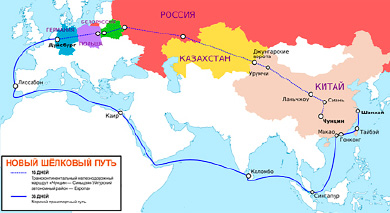
At the opening ceremony of the work program of the Belt and Road International Forum in Beijing on April 25, 2019, President of the Russian Federation Vladimir Putin indicated that the Northern Sea Route could be docked with the Chinese Sea Silk Road (a project that is also being promoted by China) (Fig. 3).

Fig. 3. New Silk Road (shown by dotted line), Maritime Silk Road (shown as solid blue line)
The implementation of this idea will connect the whole of East Asia with Europe along a shorter route. In addition, the Russian President added that this would facilitate the coordination of Eurasian countries and facilitated trade [14]. He also suggested that in the future, the project will have a great synergistic effect not only for our country, but also for the entire Eurasian region.
The optimal route for conjugation of the Northern Sea Route and the Maritime Silk Route (otherwise, the “Southern Sea Route”) is ITC “North-South”, even purely geographically. The Volga-Pechora Route (VPR) proposed here for implementation, which leads ITC “North-South” directly to the Northern Sea Route (through the proposed water system: Volga – Kama – the necessary connecting channel – Pechora).
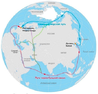
The implementation of the proposed VPR is in good agreement with the global geopolitical project of the Eurasian Canal (EAK), which can be laid between the Caspian and Azov seas along the Kumo-Manych depression (a natural depression – the channel of the ancient sea strait). Both water routes will be able to technologically interface along the Caspian Sea and in fact create the “Big European Water Ring” (Fig. 4), implementing the Eurasian Sea Route.

Fig. 4. The Northern Sea Route (shown in blue), the Sea Silk Route (also known as the Southern Sea Route, shown in red), capable of connecting them the North-South ITC (shown in purple) and the Volga-Pechora route (shown in green), as well as a hypothetical The Eurasian Sea Route, which closes the “Big Euro Ring of Water” (shown in dark green)
All this can be facilitated by the very plans to significantly increase the capacity of the Unified Deep-Water System of the European part of the Russian Federation, as the most important waterway of international importance, and the development of inland river navigation in the Russian Federation (in order to ensure the growth of traffic in the Russian European basins by 2030 in 2, 2 times (to the level of 2010), including an increase in the carrying capacity of transit cargo), according to the Strategy for the development of inland water transport of the Russian Federation for the period up to 2030 [15]. Consolidated growth of the cargo base of inland waterway transport under the implementation of an innovative scenario of economic development may reach 242 million tons by 2030, incl. while implementing the aforementioned Strategy, it is planned to build 825 new units of the fleet by the specified date.

