
Scientific journal
European Journal of Natural History
ISSN 2073-4972
ИФ РИНЦ = 0.204
MUD VOLCANOES OF THE WORLD: CLASSIFICATIONS, ACTIVITIES AND ENVIRONMENTAL HAZARD (INFORMATIONAL-ANALYTICAL REVIEW)

Mud volcanoes provide very important and useful information about complex geological and geochemical processes occurring on inaccessible depths for prospecting and exploration wells, and also play an important role in the evaluation of hydrocarbon deposits of great depths [1-4, 6, 7, 9, 11, 13-16, 18, 20, 22-24, 33, 34, 38, 41-46, 48, 50-52, 54]. One of the most important areas of the study of mud volcanism is associated with eruptions and daily activity which forms an environmental hazard. Various methods and approaches have been considered by many scientists [26-34, 35, 39, 40, 47, 49, 53] in studying this problem.
Distribution areas of mud volcanoes in the world and their classifications
There are 2508 mud volcanoes and mud volcanic manifestations within the 42 geographical areas in the world, as well as Alpine-Himalayan, Pacific and Central Asian folding zones, in the deep-water zones of the Caspian, Black and Mediterranean seas and on the passive margins of the continents [21] (Fig. 1).
Quantitatively, mud volcanic areas may conditionally be divided into the largest (more than 100 volcanoes), large (50 to 100 volcanoes), moderate (10 to 50 volcanoes), and small ones (less than 10 volcanoes) [21]. Taking it as a basis, the largest mud volcanic areas are: Azerbaijan and western slope of South Caspian Basin, Eastern Mediterranean (Mediterranean Ridge, Nile delta), Trinidad and its eastern offshore area, China, the USA (Gulf of Mexico and its coast, Barbados and Lesser Antilles Margin; large areas are: Gulf of Cadiz, Italy, Romania, Black sea, Russia (Taman peninsula and Western Kuban), Pakistan, Myanmar, Indonesia, Columbia, Costa Rica; moderate mud volcanic regions are: Western Mediterranean, Turkmenistan and eastern slope of South Caspian, Ukraine (Kerch peninsula), Iran, India, Japan, Malaysia, Georgia, Nigeria, Papua–New Guinea, New Zealand, Nicaragua, Panama, Venezuela; small areas are: Central Mediterranean, Albania, South Sakhalin, Alaska, the Philippines, Namibia, SAR, Canada, Mexico, Ecuador and Peru (Table 1).
The South Caspian Basin a zone of subsidence with a thick sedimentary stratum (more than 30 km) and a wide spread of mud volcanism [21]. The largest number of mud volcanoes, including the biggest, most frequently erupting ones and in general, all their known types (Table 2) are located in Eastern Azerbaijan and the adjacent water area of the South Caspian. It is in accordance with these factors that Azerbaijan is considered to be the “Motherland of mud volcanoes”. There are 353 mud volcanoes and their manifestations on the territory of the country (Table 3), 199 of which are terrestrial [21].
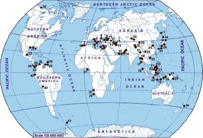
Fig. 1. Geographical location of the areas of mud volcanoes over the world: 1 – Gulf of Cadiz; 2 – Western Mediterranean (Alboran Sea); 3 – Central Mediterranean (Calabrian Arc); 4 – Eastern Mediterranean; 5 – Italy; 6 – Albania; 7 – Egypt; 8 – Romania; 9 – Black Sea; 10 – Ukraine; 11 – Russia; 12 – Georgia; 13 – Azerbaijan; 14 – Turkmenistan; 15 – Iran; 16 – Pakistan; 17 – India; 18 – Myanmar; 19 – Indonesia; 20 – Papua New Guinea; 21 – Malaysia; 22 – Brunei; 23 – Philippines; 24 – Japan; 25 – China; 26 – New Zealand; 27 – Nigeria; 28 – Namibia; 29 – South Africa; 30 – Canada; 31 – USA; 32 – Mexico; 33 – Costa Rica; 34 – Nicaragua; 35 – Panama; 36 – Columbia; 37 – Venezuela; 38 – Trinidad and Tobago; 39 – Barbados and Lesser Antilles Margin; 40 – Ecuador; 41 – Peru; 42 – Antractica
Mud volcanic areas and environmental hazard
The territory of Azerbaijan has a very complex tectonic structure and active seismogeodynamic properties [5, 8, 10, 12, 17, 19, 21, 25, 27-31]. In this regard, about 5-6 eruptions were recorded in the territory of the republic recent years (Table 4). The eruption of the mud volcano is accompanied by a powerful explosion, deep cracks extending for several kilometers, a 300-350 m high flame (with the predominance of carbon, the eruption occurs without flame) and the release of a large volume of mud volcanic breccia onto the Earth’s surface. The amount of organic matter and chemical elements of volcanic products exceeds the average statistical norms for sedimentary rocks, and this factor disrupts the natural balance of the environment. The gryphon and salse activity of mud volcanoes is accompanied by the release of gas, highly mineralized water, mud-water mixture, and in some cases, a large amount of oil. As a result, saline soils, unique volcanic landscapes, as well as oil-impregnated zones form in the mud volcanic and adjoining areas. Such landscapes are rare from the geochemical point of view and have a negative impact on the living organisms that depend on each other [27-32].
Unlike the areas of mud volcanoes spreading around the world, the eastern territory of Azerbaijan is characterized by their widest distribution (Table 1), as well as by the presence of all existing types of mud volcanoes (Table 3). This factor creates favorable conditions for the study of mud volcanism and the problems associated with it. From this point of view, Azerbaijan is a unique country for studying the impact of mud volcanoes on the environment. Taking into account the facts mentioned above, the mud volcanoes of Azerbaijan were chosen as an object of study of volcanic activity and environmental hazard.
Table 1
The distribution areas of mud volcanoes in the world
|
Geographical area |
Number of mud volcano and mud volcanic manifestation |
Geographical area |
Number of mud volcano and mud volcanic manifestation |
|
Gulf of Cadiz |
50 |
Malaysia |
29 |
|
Western Mediterranean |
10 |
Brunei |
7 |
|
Central Mediterranean |
6 |
The Philippines |
3 |
|
Eastern Mediterranean |
230 |
Papua-New Guinea |
20 |
|
Italy |
71 |
New Zealand |
12 |
|
Albania |
3 |
Nigeria |
13 |
|
Egypt |
160 |
Namibia |
1 |
|
Romania |
66 |
South Africa |
8 |
|
Black Sea |
70 |
Canada |
3 |
|
Ukraine |
43 |
The USA |
139 |
|
Russia |
46 |
Mexico |
1 |
|
Georgia |
13 |
Nicaragua |
11 |
|
Azerbaijan |
353 |
Costa-Rica |
59 |
|
Turkmenistan |
48 |
Panama |
40 |
|
Iran |
25 |
Columbia |
50 |
|
Pakistan |
52 |
Venezuela |
18 |
|
India |
12 |
Trinidad and Tobago |
202 |
|
China |
200 |
Barbados and Lesser Antillas Margin |
250 |
|
Japan |
26 |
Ecuador |
2 |
|
Myanmar |
52 |
Peru |
2 |
|
Indonesia |
97 |
Antarctica |
5 |
|
Total: 2508 |
|||
|
Terrestrial: 1107 |
|||
|
Marine: 1401 |
|||
Table 2
Classification of mud volcanoes and mud volcanic manifestations
|
Mud volcano |
Mud volcanic manifestation |
|||||
|
Terrestrial |
Marine |
Morphological type |
Crater type |
Activity type |
Mud-water mixture emitting (with oil films) |
Oil emitting |
|
Active Extinct (more than 100 years) Buried Richly oil emitted |
Island Underwater |
Cone-shaped Dome-shaped Ridgy Plateau-shaped |
Plano-convex Shield-shaped Deep-seated Caldera-shaped |
Erupting periodically Characterized by gryphon-salsa activity |
||
Table 3
Statistical indicators of mud volcanoes and mud volcanic manifestations in Azerbaijan by geological regions
|
Geological region |
Number of mud volcano |
Number of mud volcanic manifestation |
Total |
|
Pre-Caspian-Guba |
2 |
5 |
7 |
|
Shamakhi-Gobustan |
86 |
34 |
120 |
|
Absheron |
45 |
24 |
69 |
|
Lower Kura |
25 |
8 |
33 |
|
Baku archipelago |
85 |
7 |
92 |
|
Deep part of the South Caspian |
32 |
- |
32 |
|
Total |
277 |
76 |
353 |
Table 4
Mud volcano eruptions recorded within petroleum regions in Azerbaijan (during 1810-2018)
|
Volcano name |
Eruption date |
Volcano name |
Eruption date |
|
Pre-Caspian-Guba region |
Lower Kura region |
||
|
Zarat-deniz |
1953 |
Kalamaddin |
1872 |
|
Akhtarmaardy |
1990 |
||
|
Absheron peninsula |
Akhtarma-Pashaly |
1948, 1962, 1969, 1982 (twice), 1986, 2013, 2018 |
|
|
Kechaldag |
2000 |
Kichik Harami |
1912 |
|
Uchtepe |
1967, 1986, 1992, 1998, 2002, 2004, 2005 |
Hamamdag |
1938, 1947, 1967, 1984, 1996 |
|
Beyukdag |
1921, 1922 |
Agzybir |
1964, 1978, 2002 |
|
Zikh Pilpilesi |
1993 (twice) |
Bendovan |
1932, 1989 |
|
Keireki |
1824, 1830, 1865, 1882, 1885, 1902, 1915, 1952, 1953, 1957, 1964, 1966, 1968, 1989, 1991, 2001, 2002, 2014, 2017 |
Kursengi |
1965 |
|
Durovdag |
1953 |
||
|
Duzdag |
1941 |
||
|
Bozdag-Geokmaly |
1926, 1965, 2001 |
Oil salse |
1882 |
|
Bozdag-Gobu |
1827, 1894, 1937, 1953, 1957, 1974, 1986, 1987, 1999 |
Neftchala Pilpilesi |
1947 (twice) |
|
Bozdag-Gyuzdek |
1839, 1867, 1902, 1969, 1986, 1988, 1995, 2003, 2009 |
Dovshandag |
2003 |
|
Saryncha |
1936, 1976 |
Baku archipelago |
|
|
Gyzyltepe |
1914 (twice) |
Zenbil Island |
1961, 1995 |
|
Akhtarma-Puta |
1923, 1933, 1950 |
Khare-Zire Island |
1810, 1857, 1859, 1886, 1940, 1947, 1959, 1960, 1962, 1974, 1993, 1997, 2006 |
|
Lockbatan |
1829, 1864, 1887, 1890, 1900, 1904, 1915, 1918, 1923, 1926, 1933, 1935, 1938, 1941, 1954, 1959, 1964, 1972, 1977, 1980, 1990, 2001, 2010, 2012, 2017 |
||
|
Otmanbozdag |
1854, 1904, 1922, 1951, 1965, 1985, 1994, 2004, 2017 |
Gil Island |
1810, 1859, 1860, 1895, 1896, 1913, 1926, 1937, 1960, 1962 |
|
Absheron archipelago |
Garasu Island |
1876 (twice), 1923, 1977, 1993 |
|
|
Absheron shoal |
1888 |
Balygly shoal |
1868, 1913 |
|
Buzovna Pilpilesi |
1892, 1915, 1923, 1950, 1953 (twice), 2001 |
Chigil Island |
1967 |
|
Sabail shoal |
1907, 1915, 1970 |
||
|
Palchyg Pilpilesi |
1935, 1950 |
Sengi-Mugan Island |
1903, 1923, 1932, 1933, 2002, 2008 |
|
Dashly Island |
1920, 1945 |
||
|
Neft Dashlary |
1904, 1949, 1951, 1957 |
Mugan-deniz shoal |
1942, 1957 |
|
Shoal “1906” |
1906 |
||
|
Shoal “1908” |
1908 |
Chigil-deniz shoal |
1861,1927 (twice), 1928, 1939, 1950, 1959, 2001 |
|
Shoal “1933” |
1933 |
||
|
Shoal “1960” |
1960 |
Yanan-Tava shoal |
1813, 1825, 1843, 1868 |
|
Bahar-deniz shoal |
1876, 1912, 1917, 1921, 1925, 1941, 1958, 1963, 1984 |
||
|
Kapaz |
1980 |
||
|
Shamakhy-Gobustan region |
|||
|
Damirchi |
1958, 1969, 1971, 2008 |
Agnohur |
1927, 1940, 1948, 1976, 1986 |
|
Zeiva (Basgal) |
1926 |
Cheildag (west) |
1970 |
|
Kyurdamich |
1971 |
Cheildag (east) |
1870, 1957, 1968, 1970, 2004 |
|
Gizmeydan |
1987, 2001 |
Davalidag (east) |
1975 |
|
Gasymkend |
1993 |
Dashmardan |
1866, 1954, 1976, 1986, 2011 |
|
Jeirly |
1951, 1983, 2001 |
Shekikhan (west) |
1988, 1989 (twice), 2001, 2004, 2006, 2010, 2017 |
|
Hajily |
1970 |
Shekikhan (east) |
1989, 2006 |
|
Melikchobanly |
1926, 1967, 1977 |
Gotur |
1989, 2001, 2004, 2005 |
|
Gushchu |
1913, 1917, 1924, 1941, 1952, 1954, 1958, 1960, 1965, 1968, 1986, 1992, 2008, 2018 |
Toragay |
1841, 1901, 1924, 1932, 1947, 1950, 1984, 1985, 1987, 1988, 2018 (twice) |
|
Kyolany |
1845, 1962, 1969 |
Beyuk Kyanizadag |
1950, 1996 |
|
Kichik Maraza |
1848, 1970, 1986 |
Durandag |
1960, 1968, 1986, 2001, 2004 |
|
Bozaakhtarma |
1902, 1969, 1970, 1987, 2017 |
Agtirme |
1913, 1971 (twice), 1985, 1988, 1989, 1998, 2000 |
|
Shikhzarli |
1844, 1848, 1868, 1872, 1902, 1927, 1929, 1939, 1944, 1946, 1949, 1955, 1969, 1974, 1980, 1986, 1987, 1991, 1992, 1997, 2004, 2011, 2013, 2017 |
Garabujag (Hajivelieri) |
1954, 1963, 2001 |
|
Jengi |
1851,1873 |
Solakhay |
1949, 1989 (twice), 2001 |
|
Garyja |
1970, 1987, 2003, 2007, 2011, 2017 |
Garakyura |
1928, 1951 |
|
Shorsulu |
1986 |
Oyug |
1988 (twice) |
|
Sheytanud |
1975 |
Ayrantoken |
1964, 1969, 1977, 1988, 1990, 2004, 2008 |
|
Chapylmysh |
1929, 1933, 1973, 1984, 1989, 2001, 2010 |
Goturdag |
1926, 1959, 1966, 1970, 1977, 1987 |
|
Ayazakhtarma |
1926, 1969, 1973 (twice), 1985, 1989, 2001, 2005, 2006, 2007 |
Dilyangyaz |
1902, 1912, 1951 |
|
Nardaranakhtarma |
1948, 1970, 1972, 1982, 1984, |
Dashgil |
1882, 1886, 1908, 1926, 1958, 2001 |
|
Suleymanakhtarma |
1986, 1996, 2001, 2004 |
||
|
Bahar |
1853,1859, 1885, 1886, 1911, 1926, 1967, 1992 |
Alat Pilpilesi (Bala Bahar) |
1909, 1953, 1962 |
The Kichik Maraza volcano is located 38 km south-east of Shamakhi (40 °30'36.37"N, 49 ° 1'55.21"E), to the north of Shikhzarli volcano, at the hill summit of 600 m in absolute height. The hill has steep western and southern slopes and gentle northern and eastern slopes surrounded with shallow gorges and scours. An area covered with breccia is 79 ha. The mentioned volcano is placed at the Miocene sediments and confined to the northwestern pericline of the Mushkemir anticline. An outflow tongues, 40-60 m long and 5-10 m wide, are seen on the slopes. The Kichik Maraza volcano crater field is rather vast, with numerous gryphons and 0.5 m to 14 m high sopkas. Some of them are distinguished by an abundant emission of gas, water and mud with oil films. The Kichik Maraza volcano first eruption was recorded in 1848, the last one in 1986 (Table 4). The volcano is surrounded by closely adjoining agricultural and cattle breeding areas (Fig. 2 (a) and 2 (b)).
The Duzdag mud volcano is located 600 m of the Salyan-Neftchala highway (39 °22'53.76"N, 49 ° 8'46.64"E), 4 km of Khylly village. Volcanic cone, 0.6 km in diameter and 18 m in relative height, is clearly distinguished over the surrounding flat plain. The volcano is situated on the same named anticline composed of upper Pliocene and Quaternary sediments. Mudvolcanic manifestations are confined to the western regional faulting having an amplitude of 400 m and passing through the southwestern limb of the fold. A several active gryphons and salses emitting gas, muddy water, some with oil, occur on the Duzdag volcano. The last eruption of the mud volcano was recorded in 1941 (Table 4). Currently, the northern, northeastern and southwestern parts of the volcano are surrounded by an artificial lake used for agricultural and fishing purposes (Fig. 3 (a) and 3 (b)). Various phase volcanic products, ejecting from the active gryphons and salses of the mud volcano directly flow to the lake (Fig. 3 (c)).
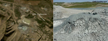
Fig. 2. Satellite image (a) and photo of the crater field (b) of the Kichik Maraza mud volcano
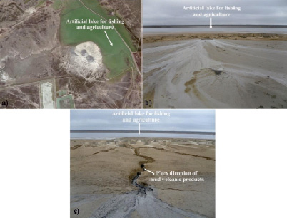
Fig. 3. The Duzdag mud volcano: (a) satellite image, (b) active salse on the crater field, (c) flows of volcanic products (water and mud mixture) towards the lake
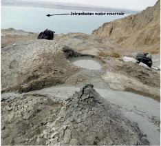
Fig. 4. Active gryphon and salse of the Kechaldag mud volcano located in close proximity to the Jeiranbatan water reservoir
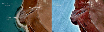
Fig. 5. Satellite image of the Kechaldag mud volcano: (a) – 2016, (b) – 2018
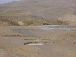
Fig. 6. Active gryphon and salses located on the crater field of the Gaynarja mud volcano
The Kechaldag mud volcano of 114 m in absolute height, is located 17 km northwest of Baku (40 °29'34.49"N, 49 °42'10.66"E), in southeastern coast of Jeiranbatan reservoir. Fragmental product of the volcano covers an area of 1000x600 m overlapping the sediments of Middle and Upper Eocene, Oligocene and Miocene which are exposed on the earth surface. Two eruptive centres of the volcano are confined to the most elevated parts of the locality (141.1 and 97.9 m). The largest, southeastern centre, towering to 44 m above surrounding locality, has 350 long and 250 m wide crater, bordered with 1.2 m high rampart (Fig. 4). The second eruptive centre located at a distance of 675 m northwest from the first centre, has a small crater. The Kechaldag volcano is confined to the northwestern pericline of a large Kechaldag-Zigilpiri anticline. The fold is complicated by longitudinal rupture with which a volcano is related. The last registered eruption of the volcano (Table 4) was related to the construction works carried out in 2000 on its slope [21].
Depends on regular changes in the water level in the Jeiranbatan water reservoir, the products of the Kechaldag mud volcano directly contact the water of the reservoir (Fig. 5 (a) and 5 (b)).
The Gaynarja mud volcano is located 8-10 km southwest of Shabran district (41 °9'16.31"N, 48 °59'2.31"E). Occuring on the Miocenic-Pontian sediments it is expressed as a hill of 60 m in relative height. A 100 m diameter crater field has many mud cones and gryphones up to 2-3 m in height and 1.5-2.0 m in base diameter, and salses of 3.0-3.5 m in diameter (Fig. 6). Gaynarja volcano is confined to the same name northeasterly trending fold which is the central link of Talabi-Zaratdeniz anticlinal belt. The fold is asymmetric with a steep (55-600) northeastern limb and gently sloping (40-500) southwestern limb. The two longitudinal dislocations of the thrust pattern have been traced on the crest. In recent years there have been no any eruptions of the Gaynarja volcano (Table 4) [29].
The artificial reduction of the minimum distance between the Takhtakorpu water reservoir and the volcano reached a peak (Fig. 7 (a) and 7 (b)). Thus, the boundaries of the reservoir were expanded without taking into account the minimum distance between the mud volcano and the basin of reservoir. Most of the crater field of the volcano, with the exception of the northeastern part, was buried underwater [28] (Fig. 7 (b). As a result, the products of the mud volcano, as in the case of the Kecaldag volcano, directly contact the water of the reservoir.
Materials and methods of research
The study were conducted on 5 active mud volcanoes (1 – Kichik Maraza, 2 – Duzdag, 3 – Kechaldag, 4 – Gaynarja, 5 – Otmanbozdag (Fig. 8)) of Shamakhi-Gobustan, Lower Kura, Absheron and Pre-Caspian-Guba regions. The visual, satellite, geological, geochemical and radioactive surveys, as well as laboratory analyzes were performed. 10 water and sopka breccia samples were collected on each volcano, and their chemical composition was determined at the Institute of Geology and Geophysics using the “S8 TIGER Series 2 WDXRF” spectrometer and the “Agilent 7700 Series ICP-MS” mass spectrometer. The organic properties of rocks (oil shales) found among mud volcanic breccias were determined in the process of two-stage pyrolysis. Radiometric measurements were carried out on multidirectional profiles passing through the crater field using radiometers “CPП-88M” and “Inspektor-1000”. A gamma spectrometric analysis of water and breccia samples was conducted to study the anomalous nature of radioactivity. In addition, based on the eruption and daily activity of some volcanoes, an approximate calculation was made to estimate the amount of gases released into the atmosphere [27-29, 39-41]. According to the data obtained, the extrapolation was carried out and the annual emission of total gas for the mud volcanoes of Azerbaijan was calculated.
Results of research and their discussion
The gas composition of the studied mud volcanoes mainly consist of CH4, CO2 and N2 (Table 5).
Table 5
Composition and average value of gases emitted from the studied mud volcanoes
|
Mud volcano |
Emitted gas ( %) |
||
|
CH4 |
CO2 |
N2 |
|
|
Kichik Maraza |
95.38 |
1.20 |
1.04 |
|
Duzdag |
95.73 |
0.53 |
1.74 |
|
Kechaldag |
95.31 |
0.64 |
2.3 |
|
Gaynarja |
92.73 |
5.64 |
1.08 |
Fig. 6. Active gryphon and salses located on the crater field of the Gaynarja mud volcano
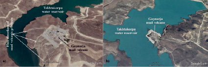
Fig. 7. Satellite image of the Gaynarja mud volcano: (a) – 2013, (b) – 2018
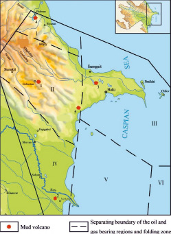
Fig. 8. Location map of the studied mud volcanoes (1 – Kichik Maraza, 2 – Duzdag, 3 – Kechaldag, 4 – Gaynarja, 5 – Otmanbozdag) within the oil and gas bearing regions and folding zone: I – Pre-Caspian-Guba, II – Shamakhi-Gobustan, III – Absheron, IV – Lower Kura, V – Baku archipelago, VI – folding zone in the deep South Caspian
According to calculations, 69.12 m3 of gas emitted from one active gryphon or salse of mud volcano (an average of 12 in each volcano (Table 4)) into the atmosphere, the total volume of which is 25228.8 m3 per year. Taking into account the fact that the most part (about 70 %) of total mud volcanoes in Azerbaijan is characterized by active gryphon and salse activity, the annual release of gas into the atmosphere is about 6231513.6 m3. Due to the fact that the volume of emitted volcanic gas mainly depends on the seismic events occur in the region [27-32], the annual total amount of gas may increase in proportion to the volcanic activity.
The calculations on the amount of gas burned during the eruption were carried out on the basis of two phases of paroxysmal events (12:20:40 and 14:18:04) that occurred on February 6, 2017 on the mud volcano Othmanbozdag (Table 4, 40 °14'25.00"N, 49 °30'26.21"E) which the largest and highest mud volcano in the world (relative altitude 404 m) (Fig. 9 (а) and (b)) located in the Absheron region of Azerbaijan. Calculations were carried out in accordance with statistical data on recorded eruptions of the mud volcano by the Republican Center of Seismological Service under the National Academy of Sciences of Azerbaijan, according to the following formula:

where h – height of the flame (the first phase is 310 m, the second is 370 m), d – diameter of the flame (the first phase is 8.5 m, the second is 12 m), T – duration of flame (the first phase is 3.5 minutes, the second is 5 minutes), t – time of complete combustion of the flame (according to [36] – 0.33 minutes). During the first phase of the paroxysm, the amount of released gas was approximately 186476.2 m3, in the second – 633709.1 m3. Taking into account the fact that at least 5 eruptions are recorded annually in the territory of Azerbaijan, and their above-mentioned parameters correspond to the eruption of Otmanbozdag, it can be concluded like the amount of ejected gas as a result of all these eruptions is 4,100,926.5 m3.
The average amount of the total mineralization of the waters carried to the Earth’s surface by mud volcanoes: Kichik Maraza – 10 g/l; Duzdag – 47.3 g/l, Kechaldag – 9.6 g/l, Gaynarja – 63.8 g/l. The mineralization of the Gaynarja mud volcano is much higher in comparison with other volcanoes. The estimates allow to conclude that the mineralization value in mud volcanoes of Azerbaijan increases from north to south. Classification types of studied volcanic waters for the Pre-Caspian-Guba and Absheron regions – sodium hydrocarbonate and calcium hypochlorite, Shamakhi-Gobustan region – hydrocarbonate sodium, Lower Kura region – calcium hypochlorite and sodium hydrocarbonate.
SO42- and K+, Ca2+, Mg2+ in the chemical composition of the water samples taken from the Kehcaldag mud volcano are below the average standards for drinking water, but Na+, Cl- and HCO3- are higher. The Ph values are corresponding to the norm. Na+, K+, Ca2+, Mg2+, Cl-, HCO3- in the chemical composition of the water samples taken from the Gaynarja mud volcano are significantly exceed the standards, but SO42- is below. The Ph indicators do not exceed the standards (Fig. 10).
The results of a comparative analysis of the microelement composition of breccia samples from the sopkas of the studied mud volcanoes show that Li, V, Zn, Rb, La, Ce, Nd, Pb, Th in Kichik Maraza, V, Cr, Ni, Sr in Duzdag, Li, V, Cr, Zn, Sr, Pb in Kechaldag sharply exceed the norm of the average value for sedimentary rocks [37] (Fig. 11).
The amount of organic matter in the composition of oil shales, found among the solids products of the studied mud volcanoes, ranges from 9.5 to 12.65 %. In the process of pyrolysis, it was established that the amount of hydrocarbons (gases) is insignificant in such rocks, and most of the organic matter is in the form of coal (Table 6).
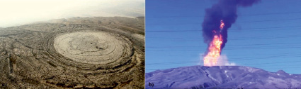
Fig. 9. The Otmanbozdag mud volcano: (a) – image from a helicopter, (b) – eruption recorded on February 6, 2017
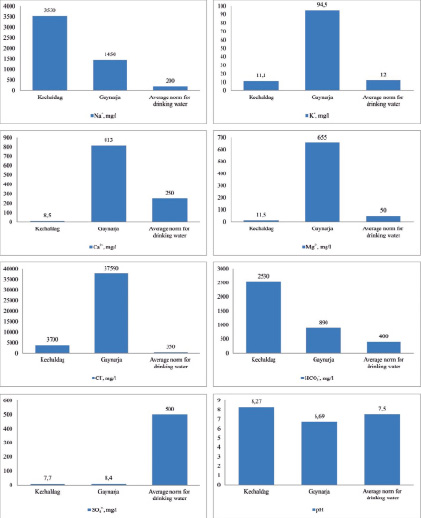
Fig. 10. Comparisons between the chemical composition of water samples taken from the studied mud volcanoes and the average norm for drinking water
Table 6
The results of the two-stage pyrolysis of rock samples taken from the Gaynarja mud volcano
|
Sample |
Organic matter, % |
500-550 °C |
800-850 °C |
||
|
Oil |
Gas |
Oil |
Gas |
||
|
1 |
12.2 |
- |
2.43 |
- |
2.67 |
|
2 |
12.65 |
- |
4.99 |
- |
1.88 |
|
3 |
9.5 |
- |
5.24 |
- |
1.20 |
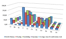
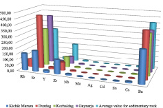
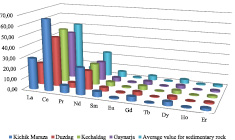
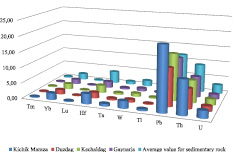
Fig. 11. Comparative analysis between the microelement composition of breccia samples taken from the studied mud volcanoes and average values for sedimentary rock [37] (ppm)
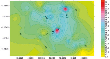
Fig. 12. Distribution map of the radioactivity in the crater field of the Gaynarja mud volcano
Table 7
The content of radionuclides in the water samples from gryphons and salses of the Gaynarja mud volcano
|
Radionuclide, Bk/l |
Sample |
Average concentration for drinking water Bk/l |
||
|
1 |
2 |
3 |
||
|
K 40 |
25.6 ± 4.2 |
15.2 ± 1.4 |
16.6 ± 1.9 |
22.0 |
|
Ra 226 |
0.228 ± 0.054 |
0.154 ± 0.024 |
0.126 ± 0.028 |
0.5 |
|
Ra 228 |
0.138 ± 0.010 |
0.324 ± 0.050 |
0.644 ± 0.036 |
0.2 |
|
Rn 222 |
0.20 ± 0.12 |
0.18 ± 0.10 |
0.10 ± 0.06 |
120.0 |
|
U 235 |
0.0144 ± 0.0032 |
0.0064 ± 0.001 |
0.0120 ± 0.0016 |
3.0 |
|
U 238 |
0.312 ± 0.069 |
0.139 ± 0.021 |
0.261 ± 0.034 |
3.1 |
Table 8
Specific activity and content of radionuclides in the breccia samples of the Gaynarja mud volcano
|
Sample |
Integral radioactivity mR/h |
Activity, Bk/kg |
U, Bk/kg |
Th, Bk/kg |
К, Bk/kg |
|
1 |
23 |
481.56 |
431.81 |
– |
634.61 |
|
2 |
14-15 |
106.4 |
50.19 |
0.45 |
704.87 |
|
3 |
16-17 |
118.51 |
12.15 |
77.99 |
208.42 |
|
4 |
23 |
515.12 |
480.15 |
– |
671.71 |
The radioactivity of the breccia on the crater field of the Gaynarja mud volcano is 9.5-23 mR/h. Lower values of radioactivity were recorded in the central, northern and northeastern parts of the volcano (Fig. 12). This can be explained by the presence of tectonic dislocations in these zones.
The amount of radionuclides (Ra 228 in two samples, K 40 in one sample) in water samples taken from the active gryphons and salses of Gaynarja mud volcano sharply exceeds the average concentration of radionuclides for drinking water. The concentration of radionuclides Ra 226, Rn 222, U 235 and U 238 is much lower than the norms (Table 7).
Radionuclides Ra 228 and Ra 222 were not detected in the breccia samples. Analyzed samples were selected in the zones of both weak and relatively high radioactivity. Thus, the average indicator of radioactivity of rocks ranges between 106.4 and 515.12 Bk/kg (Table 8). These indicators reflect the overall complex level of gamma rays, and depend on the amount of radionuclides in the rock composition. Exceeding the level of gamma rays in two rock samples can be explained by the presence of a uranium element in their composition. The amount of thorium does not exceed the mean value, and potassium is present in all volcanic rocks.
Conclusions
The content of gases released into the atmosphere as a result of the eruption and daily activity of mud volcanoes in Azerbaijan, mainly consist of CH4, N2 and CO2. The total amount of these gases per year is more than 10 300 000 m3, that CH4 dominates in concentration (more than 90 %). The obtained results show that volcanic gas emissions have a serious influence on the overall gas budget of the atmosphere.
The total level of mineralization in volcanic waters is high, on average more than 30 g/l. The classification types of these waters are sodium hydrocarbonate and calcium hypochlorite. Na+, K+, Ca2+, Mg2+, Cl-, HCO3- are significantly higher than the average allowable value for drinking water in some samples. The radionuclides Ra 228 and K 40 were found in the water samples that their concentration is also much higher than the norm for drinking water.
Some microelements, such as Cr, Ni, Sr, Pb and Th were found in the breccia composition of mud volcanoes, that their concentrations are significantly higher than the average value for sedimentary rocks. The amount of organic matter in the rocks, ejected by mud volcanoes, is more than 9 %. The results of pyrolysis show that the yield of hydrocarbons is insignificant, organic matter is most often in the form of coal.
Radioactive backgrounds on the crater field of the mud volcano were often increased, which is explained by tectonic dislocations in the internal structure of the volcano. An increase in the gamma level in some breccia samples selected in areas with a high radioactive background is associated with an increase in the concentration of uranium.
This work was supported by the Science Development Foundation under the President of the Republic of Azerbaijan – Grant № EIF/GAM-3-2014-6(21)-24/11/2.
Библиографическая ссылка
Baloglanov E.E., Abbasov O.R., Akhundov R.V. MUD VOLCANOES OF THE WORLD: CLASSIFICATIONS, ACTIVITIES AND ENVIRONMENTAL HAZARD (INFORMATIONAL-ANALYTICAL REVIEW) // European Journal of Natural History. 2018. № 5. ;URL: https://world-science.ru/en/article/view?id=33923 (дата обращения: 22.07.2026).